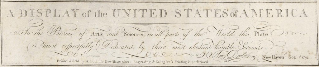
A display of the
United States of America
By
Amos Doolittle
Oct. 1791, New Haven, Ct.
Medium: Engraving / Demensions W: 48.3 x H: 57.2 cm / Location: Museum of Fine Arts, Houston, TX
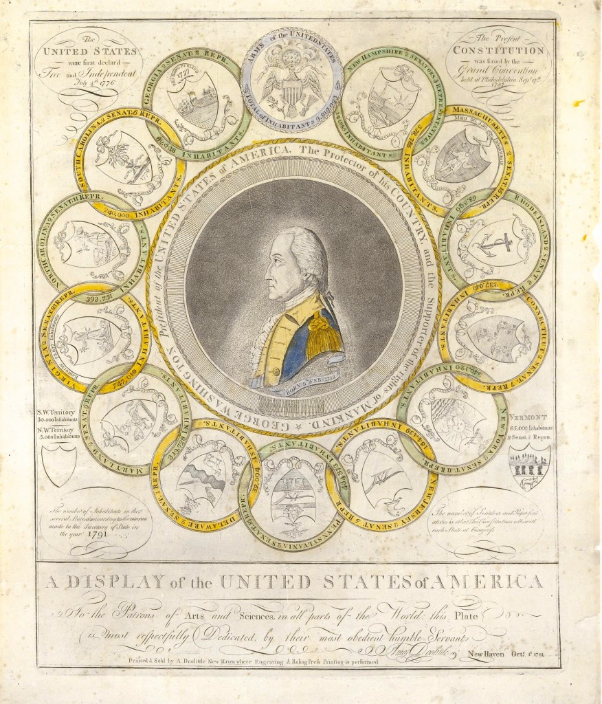
The Arms of the United States
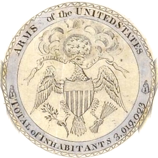
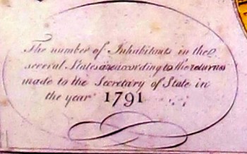
Total Inhabitants: 3,019,023
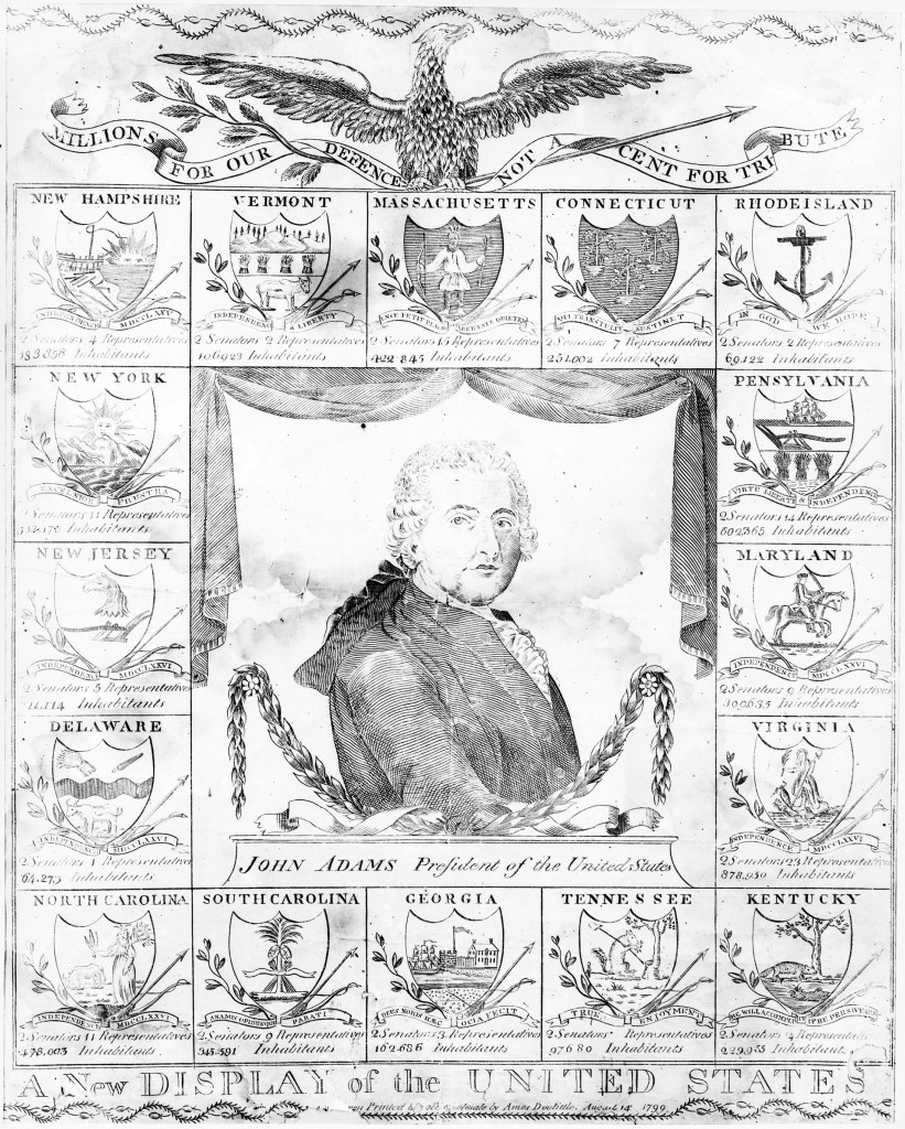
The Military III’s Signifies that George Washington was only able to get 3% of the Colonists as an active military force in the Continental Army to fight against the British. Even though they were supported by perhaps 10% of the 13 colonies population. The population break-down was most likely 20% who favored the Patriot Cause but did little or nothing to help support it. Another one-third of the population who wanted to be British Subjects sided with King George III. The last third decided this was not their fight and took no side and blew with the wind and took whatever fortune people of higher stations deemed appropriate. The sad part was there was more Loyalists actively fighting on the field with British soldiers then against them!
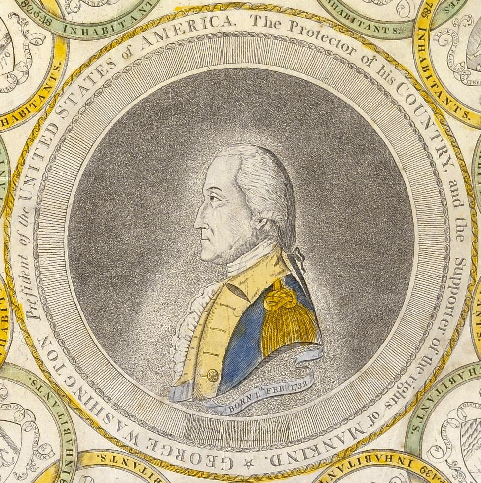
George Washington President of the United States
The Protector of his Country
&
The Supporter of the Rights of Mankind
Library of Congress Description
Doolittle’s 1788-89 engraving “A Display of the United States of America,” which has a bust portrait of George Washington, encircled by the seals of thirteen states in the form of circular links in an unbroken chain, symbolic of the federal union.
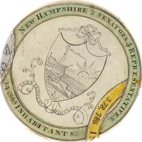
New Hampshire: 14,885 Inhabitants
*
Massachusetts: 378,785 Inhabitants
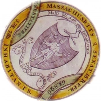
The official name of the state is, “The Commonwealth of Massachusetts,” or is simply referred to as, “The Commonwealth.” The early colonists took the name Massachusetts from the Algonquian Indian term, “Near the Great Hill,” or “By the Blue Hills.” Massachusetts is located in the New England region of the northeastern United States, and lies on the coast of the Atlantic Ocean. It is bordered by Rhode Island and Connecticut to the south, New York to the west, and Vermont and New Hampshire to the north. Massachusetts was originally formed from three distinct settlements. Plymouth near Cape Cod, Gloucester on Cape Ann, and Mass. Bay Colony around Boston. The first English settlers were known as Pilgrims, and they came to Plymouth, Massachusetts in 1620. They developed friendly relations with the native Wampanoag Indians, and this became the second successful permanent English colony in North America after Jamestown. In 1630, the Puritans soon followed and established the Massachusetts Bay colony. This is what we know in present day as Boston. Unlike the Plymouth colony, the Bay colony was founded under a Royal Charter by the Puritans. They were seeking religious freedom from the Church of England. In 1691, both the colonies (& Maine) were united into the Province of Massachusetts Bay. The new governor of the Province, Sir William Phips, is the one in which the Salem Witch Trials took place. This resulted in a number of men and women being hanged or burned. In the late 18th Century, Boston became known as the “Cradle of Liberty” because of the agitation of it’s colonists that led to the American Revolution, and the independence of Colonies from Great Britain. Later on in the Federal Period around 1780, John Adams who was known as, “The Atlas of Independence” wrote Massachusetts’s original Constitution. This was the first state to have a Constitution that declared the universal rights for it’s citizens. Also in 1780, Nathan Cushing designed the Massachusetts’s Coat of Arms. This depicts a standing Native American Indian holding a Bow in his left hand, and an Arrow in his right. There is a five-pointed North Star over his right shoulder which represents the dependent territory of Maine. The Commonwealth’s Latin motto, “Ense Petit Placidam sub Libertate Quietem,” means “This Hand the Rule of Tyrants to oppose, Seeks with the sword fair freedom’s soft repose,” This prompted the adoption of a Sword and Arm as the unofficial crest. Most of the Massachusetts Militia buttons depict either the Arm & Sword, or the Standing Indian. The earliest known use of a military button depicting an Arm and Sword would be Henry Jackson’s independent Boston Militia in 1776. By the early part of the 19th Century, Massachusetts operated with a large number of undisciplined militia units who were ceremonial in nature. It wasn’t until 1840, the state started to re-organize all these rouge companies in order to create a more disciplined volunteer system. By 1851, they had integrated most of the independent companies into regiments and battalions. The companies who wouldn’t join and opposed the new reorganization soon disbanded.
*
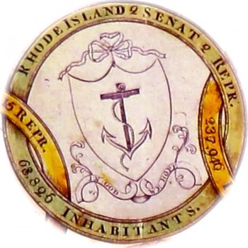
Rhode Island 68,826 Inhabitants
*
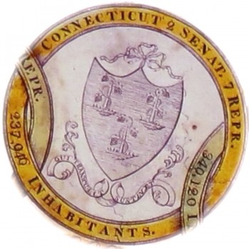
Connecticut 237,940 Inhabitants
*
New York 340,120 Inhabitants
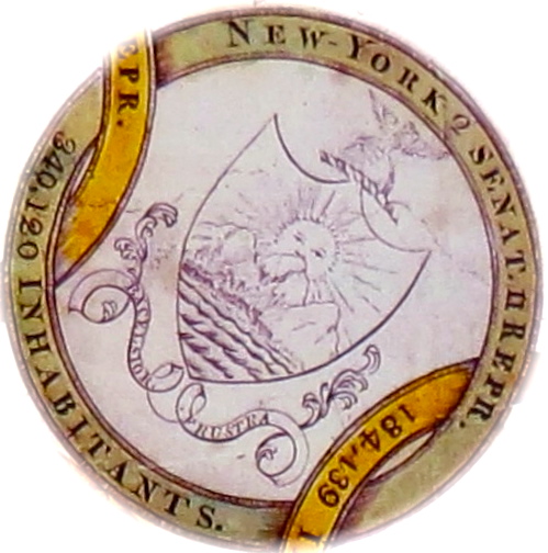
In the pre-colonial era, The City of New York and it’s surrounding areas were inhabited by the various bands of the Algonquin Indian tribes. The actual first visit to New York by a European was in 1524 by Giovanni da Verrazzano. He was a Florentine explorer in the service of the French Crown. He sailed his ship, “La Dauphine” into upper New York harbor, where he spent one night aboard his ship, and then sailed out the next day. Giovanni claimed the land for France, and named it, “Nouvelle Angouleme.” The following year in January of 1525, a Portuguese sailor who was commissioned by the emperor of Spain entered New York Harbor, and chartered the mouth of the Hudson River. He named it Rio de San Antonio. He would have sailed down the Hudson River, but the heavy ice kept him from exploring any further. New York remained for the most part untouched by the rest of the world until 1609, when an English explorer named Henry Hudson sailed his boat the Halve Maen (Half Moon) into NY harbor, and re-discovered the region. Hudson was commissioned by the Dutch East India Company to find a faster trade route to the Orient (Northwestern passageway). He sailed up the Hudson River for 10 days ( as far as Albany) thinking it could be a passageway, but then turned around when he realized the river was no longer salty and narrowed. A few more years passed, and then in 1614 the Dutch founded a fur trading settlement on the southern tip of Manhattan, which was later called, “New Amsterdam” in 1625. The Dutch West India Company was then chartered in 1621 to settle a new North American colony called,“New Netherlands.” This establishment was based on giving large land grants to a handful of quasi-feudal landlords with little or no governing populations; rather then conveying the land to young eager settlers. After a few years, the new settlers of the Dutch Republic established a trading post in 1624. We accredit this establishment to what we we would call the “grass roots” of New York.
This colony slowly began to populate, and then by 1664, the city and all of it’s surroundings came under English control, and was renamed, “New York.” Fearing bloodshed, Peter Stuyvesant who was the Director-General of the colony of New Netherlands surrendered New Amsterdam to King Charles of England who in-turn granted the lands to his brother, The Duke of York. While under British rule, NY became one of the most important trading ports throughout the world. By 1730, it became the center of the slave trade, and was just under Charleston South Carolina with more then 42% of all households owning slaves. By 1776, anti-British sentiments swept through the city, and setting a stage for one of the largest battles of the American Revolution. The Battle of Long Island took place in August 1776, in what we know as modern day Brooklyn. With heavy casualties and being outnumbered, the Americans patriots fled along with sympathizers of the cause. New York quickly became the military and political base of operations in North America for the British Crown. In the next few years, New York became a haven for Loyalist refugees and escaped slaves who were quick to join the British line for a promise of freedom. In 1777, the Americans were able to contain the british to the city part of the state with a major victory in Saratoga- Lake Champlain/ Hudson River corridor. A State Coat of Arms was adopted in 1777, which shows a river and mountains in-front of a rising sun. The Crest depicts an American Bald Eagle perched on the top of a Terrestrial Globe. A figure of Liberty supports the shield on the left hand side, and Justice is to the right. Beneath the shield is the motto, “Excelsior” which means higher. Many early militia buttons used the Crest of the Eagle on top of the globe, but only a few carried the complete Coat of Arms on their device. By the Civil War, many common buttons sported the state military seal which links the State of New York, and the United States Arms on a shield to symbolize the twin allegiance of her militia. By 1862, the different militia units used variants of the Eagle and Shield Design.
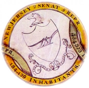
New Jersey 434,373 Inhabitants
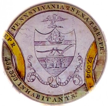
Pennsylvania: 434,373 Inhabitants
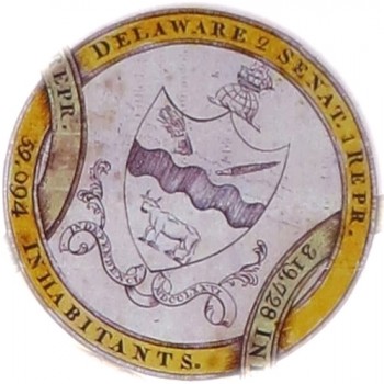
Deleware 59,094 Inhabitants
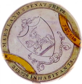
Maryland 319,728 Inhabitants
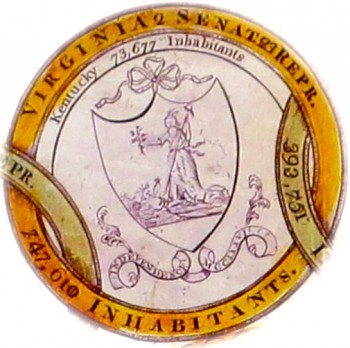
Virginia 747,610 Inhabitants
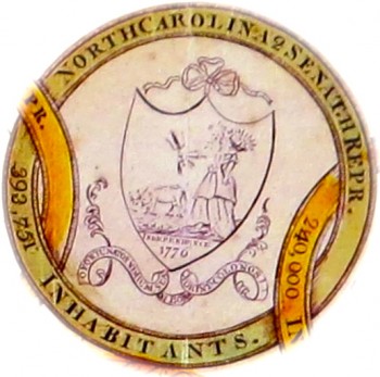
North Carolina 393,751 Inhabitants
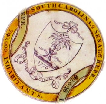
South Carolina 270,000 Inhabitants
South Carolina is located in the Southeastern United States. It is bordered by the Atlantic Ocean to the East, North Carolina in the north, and the Savannah River to the west with Georgia. The name Carolina takes it’s name from Charles I; which is Latin for “Charles land.” Originally Spain colonized the coastal areas, but frequent battles between the Native Americans caused the Spanish people to retreat to Florida, Cuba, and Mexico. Then a colony of Carolina was established by British settlers from Barbados; and shortly after in 1670, King Charles gave eight aristocrats a Royal Charter, and they sponsored the first permanent settlement in Charleston. At this point there was no North or South Carolina, it was solely the Province of Carolina. John Locke who was an English philosopher wrote a constitution for the colony that covered topics for land division and social ranking. This caused settlers not to buy land there, and after a time proprietors were forced to lower prices to attract new settlers. The Province of Carolina did not develop as planned because of political reasons, and this caused a split creating two different colonies. In 1719 settlers in South Carolina wanted more political power and seized control from it’s proprietors. This rebellion failed, and the King assumed jurisdiction for a short time. Then in 1729, Carolina became two Royal Colonies– North Carolina and South Carolina. Farmers from Virginia moved into North Carolina and grew tobacco and sold timber and tar to the English Navy. Since North Carolina lacked a good harbor, they used Virginia’s ports to conduct their trade.
As settlements spread in South Carolina, more Germans and Scotch-Irish moved up from Virginia and traded in deer skin, lumber, and beef. South Carolina farming prospered from the fertility of their Low-Country, and the use of good harbors such as, Charlestown. The Low Country ended up creating and earthworks of dams and canals which irrigated rice fields and indigo plants. Indigo is a blue flowering plant which was used to dye textiles. This became a major commodity crop for South Carolina. Slave labor slowly became an integral part of South Carolina’s economic success for farming. By the time of the American Revolution, slaves exceeded the number of Anglo-European colonists. In March of 1776, the colony adopted the first constitution of South Carolina and it became the first Republic in America; and John Rutledge was elected as the first President. After the Battle at Sullivan’s Island in 1776, South Carolina approved their Coat of Arms design. It depicts a Palmetto Tree on a seashore, which is suppose to be symbolic of a Revolutionary fort built that was built on Sullivan’s Island by Palmetto Trees. At the base of the Palmetto is a broken Oak Tree which symbolizes the British fleet. Twelve Spears are bound to the Palmetto’s trunk which represents the other twelve colonies. A band that ties the spears is inscribed in Latin, “Quis Separabit” which means, “Who shall separate.” Beneath the oak is another Latin inscription, “Meliorem Lapsa Locavit” which means, “Having fallen, set up better”; which basically means the decline of British control and the ascendance of South Carolina.
The state also adopted a motto,“Animis Opibusque Parati” which means, “Prepared in Mind and Resources.” (In 1831-32, Gov.Hamilton placed the first order to Scovills with this design and motto in defiance to the Federal Gov. Policy on Tariffs. The states militia used these buttons several years later). In February of 1778, South Carolina became the first state to ratify the Articles of Confederation. In later years during the Federal Period of 1783-95, politics was split between the Federal elite who supported the central government in Philadelphia, and the large portion of common people who wanted more democracy. As far as foreign affairs, most people supported the French Revolution (1789-95). Charleston was one of the most French influenced cities in America. Leading figures such as Governors Charles Pinckney and William Moultrie backed with money and political support French commercial goals in North America. This pro-French stance ended soon because of the XYZ Affair, and Frances refusal to accept C. Pinckney US Ambassador. By the beginning of 1800, with the increasing value of cotton, ordinary farmers shifted into slave major holders. With the collapse of the cotton prices in the late 1820’s and 1830’s, South Carolina went into a major economic crises. This was mostly blamed on the Federal Tariffs Laws of 1828 & 32, in which northern tariffs were placed on foreign manufactured goods. In 1832, John Calhoun tried to nullify the Federal Tariff Act but failed because President Andrew Jackson responded to the crises with the threat of force. As the years progressed, festering problems of northern domination and slavery led to another convention in Charleston, and in December of 1860, South Carolina became the first state to leave the Union. Shortly after hostilities commenced when Cadets from the Citadel fired on the Federal ship, “Star of the West” while attempting to supply Fort Sumter.
Georgia 89,548 Inhabitants
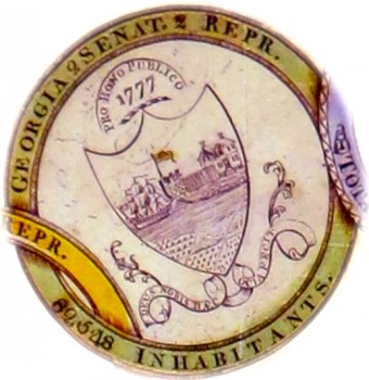
Georgia is located in the southeastern part of the United States. It is bordered by Florida in the south, South Carolina & Atlantic Ocean in the East. To the west is Alabama, and it’s northern borders brinks upon North Carolina and Tennessee. Georgia was the last of the original 13 colonies to be established in 1732. It was named after King George II, who charted the region to James Oglethorpe who established a settlement in Savannah in 1733. Originally it was created to be a buffer between the British colonies to the north, and the Spanish territory of Florida in the south. Between 1770-1840, settlers from Virginia and the Carolinas began to colonize the interior of the state and force the Creek and Cherokee Indians out of their lands. In 1861, Georgia joined the Confederacy, and was the 5th state to secede from the union. In 1799, the Georgia legislature adopted a State Seal, or Coat of Arms depicting Three Classical Pillars supporting an Arch bearing the word, “Constitution”. The design symbolizes the three branches of government; Legislative, Judicial, and Executive supporting the ratified Constitution. Wrapped within the pillars is a banner inscribed with the words, “Wisdom, Justice, and Moderation.” On the side of one of the pillars is a Minuteman with a Drawn Sword symbolizing the defense of the constitution by state military forces.
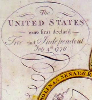
Declaration Cartouche:
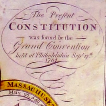
Constitution Cartouche:
1791 Cartouche:
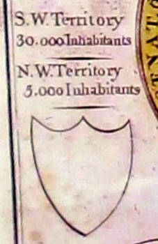
South West Territories Inhabitants:
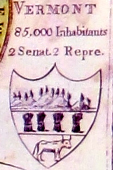
Vermont Shield & Rep.:
A New Display of the United States
By
Amos Doolittle
1799
John Adams President of the United States